Monday, August 12, 2013

Château des ducs de Bretagne

Location: 47°12′57″N 1°33′0″W

Medieval states often did not have a capital in the modern sense. Rulers moved around a lot and lived in various places throughout their territories, but they usually had one main residence in an important city. In that sense, Nantes was the capital of the Duchy of Brittany. There were other castles elsewhere in Brittany, and other large and important cities which also served as "capitals", such as Rennes and Vannes. But as the usual residence of the dukes, Nantes naturally needed a large castle. The modern name of the castle, the "Château des ducs de Bretagne" reflects this necessity. It also reflects the sentiment that Nantes is still a part of Brittany, even though it was separated into a different province after the Revolution.

Remnants of the Maison des
Engins in Place du Bouffay.
Nantes' original castle was located in Le Bouffay, the ancient and medieval core of the city. That's where all narrow streets and tall wooden houses are located. When Nantes was recaptured from the Vikings in the 10th century, the first castle was built there, within the Roman walls. Parts of that castle remained intact up to the 18th century, but nothing remains of it now. There are some remnants of buildings that were attached to it in the modern Place du Bouffay, like the chimney from the Maison des Engins (Nantes' first city hall), and the Église Sainte-Croix, which was originally the castle's chapel. The sculpture on top of the church was part of the Tour du Bouffay, a medieval tower that has also been destroyed.

As I mentioned in previous posts, Brittany was independent, but almost always under either English or French influence. In the early 13th century, relatives of the king of France married into the ruling dynasty in Brittany. The French dukes built new walls, partly to improve the defences of the city, but partly also as a display of French influence. They also built a new castle.


The Vieux Donjon.
 The new castle was built along the southeast corner of the new walls (which in that part of the city simply followed the line of the Roman wall). The first structure built there no longer exists. The earliest remaining part of the castle, the "Vieux Donjon," was built in the mid-14th century, during the War of the Breton Succession and the Hundred Years' War between France and England. At first it seems like just another part of the castle, but looking at it more closely, it is obviously different from the rest. And looking directly to the north, you can see that it lines up exactly with the remains of the medieval and Roman walls on the Cours St-Pierre.

I assume the castle was connected to the system of medieval walls, but I'm now sure how. Some of the castle's walls have a distinctive pattern of stones, reminiscent of the Roman wall (but entirely in large grey stones, no small stones or red bricks). The remnant of Porte Sauvetout has the same pattern, but the other remnants of the medieval walls don't look like that. In any case, today the castle is a completely separate structure, and wherever it was connected to the walls, that connection no longer exists.

My son and I at the castle in 2011 (my wife is a much better
photographer than me and has a much better camera)
When I first arrived in Nantes and I lived in the residence for foreign researchers, I could see the cathedral and the castle in the distance. They were the only medieval remnants I knew about at the time, and it took me a few weeks to go visit them, because I didn't want to ruin the mystique. Actually the first time I went to the castle, my family and I were just wandering around the old city and happened to end up there by accident. It's not very big, for a French castle, but it was the biggest castle I had ever seen. (Of course, the only other castles I had seen were Casa Loma in Toronto and the Magic Kingdom in Disney World.)

The south wall and the modern artificial moat, on a rare
snowy day in 2012 (apparently this was the first time it had
snowed in Nantes in 16 years). Originally, the castle was
located on the banks of the Loire river, which has since been
diverted to the south.
It also looks like it's built into a ditch, at a lower level than the rest of the old town. The castle at Ancenis also looks like that, because the rest of the town has been built up on several layers of road since then. That has happened in Nantes too, but the courtyard of the castle is actually at the same level as the rest of the city. The foundations, however, are lower down because they used to be underwater. Before the north branches of the Loire were covered over in the 19th and 20th centuries, the castle used to sit right on the banks of the river, which was handy for defense and for controlling trade. The river also served as the castle's moat. There is still a
One of the towers (facing the old course of the Loire),
with its arrow/crossbow holes still visible.
shallow, artificial moat there, but the rest of it has been turned into a park, full of ducks and turtles. I assume that at least some of the walls surrounding the park (the ones not connected to the castle itself), were part of the medieval wall system, but I'm not entirely sure about that either.

The castle, along with the château de Pirmil on the south side of the Loire, and the various other castles stretching to the north and the east along the border with France, protected Nantes during the War of the Breton Succession and
The Conciergerie, one of the buildings constructed after
Brittany was annexed to France.
the Hundred Years' War. After France's victory in the Hundred Years' War in the 15th century, Brittany remained an independent duchy for another hundred years. The dukes of Brittany expanded the castle, constructing most of the buildings that still exist today, like the "Grand gouvernement" and the "Grand logis" and its tower, the large white buildings that are the most impressive part of the interior.


The Harnachement, another one of the later buildings.
I notice I have no pictures of the Grand Logis...
unfortunately it was too big for my camera.
The kings of France, however, had brought most of the rest of modern France under their direct control, and they were certainly not going to let Brittany remain independent forever. The duke, Francis II, had fought against France in the "Guerre folle", the "Crazy War", in the 1480s. He was defeated in 1488 and died later that year. His daughter, Anne, had married the Holy Roman Emperor, an enemy of France, but was forced to annul that marriage when she was taken prisoner by the French. Brittany was allowed to remain independent, but Anne then married the king of France, so the two nations were now united. Early in the 16th century, Brittany was officially annexed to France during the reign of Anne's daughter.

Anne, Duchess of Brittany and Queen
of France. This statue depicts her as a
typical Breton peasant, which she
definitely was not.
It's simple to say that the kings of France simply wanted Brittany because they had to fulfill their idea of what was supposed to be part of France.  But there was also another very good reason for having Brittany under royal control: it was full of port cities, and it was the closest part of the country to the Atlantic Ocean and the newly discovered North and South America.

Although I'm a medieval historian, but originally I wanted to study the history of the French colonies in Canada in the 17th century. To me, the castle in Nantes represents both of these interests. Those colonies would not have existed if France had not been able to send expeditions from the ports of Brittany. Jacques Cartier was from St-Malo in Brittany, and sailed for Canada in 1534, the same year that the duchy was officially annexed. Many of the settlers of New France were from Brittany, and today there is even a Quebec town named Nantes. 


The outline of one of the towers that
exploded in 1800. (The wood in the
background is just for flower boxes.)
Anyway, now that the castle was no longer necessary as a defense against France, it became the residence of the French governors of Brittany, as well as a secondary palace for the kings of France. Throughout the 16th and 17th centuries, new buildings were built in the courtyard, and the existing ones were refurbished. The castle was still used for defense during the Wars of Religion during the Reformation in the 16th century, and King Henry IV may have signed the Edict of Nantes there in 1598, temporarily granting religious freedom to French Protestants (until it was revoked about 90 years later). The Edict of Nantes was basically the only thing I knew about Nantes before I lived there. No one really knows where it was signed though. Another traditional spot was a house to the west of the old city (in the modern Médiathèque quarter), which was destroyed by bombing during World War II.

In the 17th and 18th centuries, the castle was also a prison, as were many other castles and abbeys throughout France. In 1789, it was captured by revolutionaries after they learned about the fall of the Bastille in Paris. The Revolution was brutal in Nantes. The guillotine was set up on the site of the former castle in Place du Bouffay, and there were supposedly a lot of "Republican marriages", where men and women who were condemned to death were tied together and thrown into the Loire to drown. The counter-Revolution, the Vendée War between the revolutionaries and the royalists, ravaged the countryside around Nantes. The royalists were defeated at Nantes in 1793, one of the most important events of the Revolution.

In 1800, during the reign of Napoleon, one of the towers of the castle was being used as an artillery depot. The tower exploded, destroying a large part of the castle and the city (including all the windows of the cathedral). The damage is still visible in the castle, as there is an obvious missing tower (otherwise, it would be symmetrical, as it would match the tower on the opposite side), and the parts that had exploded were rebuilt with simple bricks in a completely different style. The foundations of the exploded tower and of the parts of the wall that were destroyed are still visible in the ground, and there are now a garden inside of them.

The castle full of tourists in July, 2012.
Since the early 20th century the castle has been used as a museum. The current museum covers the entire history of Nantes. It starts at the bottom of the Grand gouvernement and Grand logis, and works its way up through history until you reach the top floors. The bottom two floors are the most interesting for me, dealing with the prehistoric, Roman, and medieval periods. Unfortunately (for me), the events that the city considers to be most important all happened after that. Nantes was a major port in the Atlantic slave trade, so a lot of the museum deals with that (and in 2012 a new museum opened in the western part of the city, dedicated specifically to slavery). There is also a lot of fascinating stuff about Nantes during World War II. It's all very interesting, and a fun way to spend a day, but it really takes almost the whole day to appreciate the entire museum. On one floor there is an interactive computer program that lets you explore Nantes as it may have looked in the 18th century. I may have spent hours wandering through that program alone.

You can always walk around the walls for free, but the museum usually costs money. It's free on Sundays, except during tourist season in July and August.


History museum


Here are some interesting things in the history museum:

Since I was unable to take a picture of the whole castle, here is a model of the entire thing:


And here is a model of medieval Nantes, within the expanded walls of the 13th century (in the background is a 16th-century tapestry):


Another thing the Loire was useful for was waste disposal. Here is a medieval toilet, opening right over the river:


I didn't take many other pictures, since there are dozens of rooms and most of it is about Nantes' more recent history. But here is a pirate treasure from the 18th century. It's right out in the open, so I absent-mindedly tried to open the chest, until a security guard told me not to touch it:


Now that I am writing this, I wish I had taken far more pictures of all the interesting parts of the castle. I walked past it on the way to work and back every day, and I guess I started taking it for granted. I thought I could go back and take pictures whenever I wanted, but now I can't, and there are lots of things I wish I could illustrate better here.

Friday, August 2, 2013

Oudon, Champtoceaux, Ancenis

Oudon and the Loire, from the top of Oudon Castle.
As I mentioned in the previous post, the medieval walls of Nantes were built in the early 13th century, at a time when the French king was expanding his control over all the territory that is now part of modern France.

The kings ruled the area around Paris, the parts they had conquered from the English in the 13th century (Normandy, Anjou, and some other places), and some of the south (which had previously also been independent, and is still very different today). The kings of England also ruled the parts of France they had inherited in the 12th century that had not yet been conquered by the French (Aquitaine, south of Brittany along the Atlantic coast).

Although Brittany was independent, a cousin of the king of France had married the duchess of Brittany. The new French duke built the new walls of Nantes, and of many other Breton cities. The construction of new walls was one way to impose French authority over Brittany, but it also helped protect Brittany from being attacked by the English.

Statue of Joan of Arc in the
Basilique St-Nicolas in Nantes.
For the rest of the 13th century Brittany remained under French influence. However, the history of Nantes and Brittany gets much more complicated in the 14th century. England always claimed the parts of France that had already been conquered by the French, and through various marriages between the English and French royal families, the English now also claimed all of the rest of France too. This led to the Hundred Years' War in the 14th and 15th centuries, and England did in fact conquer a big part of France for awhile (until, among other reasons, they were defeated by Joan of Arc).

The French dukes of Brittany played both sides against each other to avoid being conquered by either one. Now the walls of Nantes and of the other cities of Brittany were also used to protect the independence of Brittany from both the English and the French.

Meanwhile, there was also a civil war in Brittany, over who was the rightful heir to the duchy (the "War of the Breton Succession"). I was trying to avoid turning this blog into a boring list of names and dates, but they're important here: the duke, John III, died without children in 1341. Brittany was then claimed by his half-brother, John of Montfort, on the one hand, and John III's niece Joanna of Penthièvre. Penthièvre was basically the north coast of Brittany, and its rulers had always been relatives of the dukes of Brittany. Joanna was married to a nephew of the king of France, so the French monarchy supported the Penthièvre faction. The English, naturally, supported the Montfort side. In the end, the Montforts won, but the war lasted until 1364, and the Penthièvre family never fully gave up their claim to Brittany.

Throughout the rest of the Hundred Years' War, Brittany passed between French and English influence. The war finally ended in 1453, when England was expelled from France. Brittany remained independent, at least for a few more decades.

Oudon

Ruins of Oudon castle.
Location: 47° 20′ 44″ N, 1° 17′ 21″ W  

There are lots of sites in Brittany that were affected by the Hundred Years' War and the War of the Breton Succession, but Oudon and Champtoceaux are related to one funny event in particular. Oudon was one of the last Breton castles on the Loire, on the border between Brittany and French-ruled Anjou. It's still on the border, as Oudon is in the modern département of Loire-Atlantique (along with Nantes) and Champtoceaux is in Maine-et-Loire (the historical Anjou). A new castle was built in Oudon in the 14th century during the Hundred Years' War.

There is not much left of the castle, except for the tower. The tower is actually what got me interested in the local history of the area. The train to Paris passes by Oudon, so one day I took the train there instead (about 20 minutes away on the regional train). There is a museum inside the tower, which deals with Oudon's history as a fishing town and its location on the border with Anjou/France. You can climb all the way to the top, where there is a nice view of the Loire valley (the panorama at the top of this page), and of Champtoceaux across the river.

As I wrote about earlier, Oudon is also the site of a Neolithic standing stone.

Champtoceaux

Statue of Duke John VI,
in Nantes Cathedral.
Directly across the river from Oudon there was a much larger castle, then known as Chateauceaux ("Castle Ceaux"). It was built on top of a cliff overlooking the Loire, a good position to see any army that might be marching into Anjou from Brittany. In 1420, the dispute over the succession between the Montfort and Penthièvre families flared up again. The Penthièvre family disregarded the treaty that ended the civil war 60 years earlier. They kidnapped the Duke of Brittany, John VI (the grandson of John of Montfort), and imprisoned him at Chateauceaux. They claimed that John was dead, and that they should therefore inherit the Duchy of Brittany. The Montfort family didn't believe it, and eventually figured out that John VI was in Chateauceaux. John was released, but did not forgive or forget what had happened, and took his revenge on the Penthièvre family by destroying Chateauceaux.

He destroyed the castle so thoroughly that almost nothing of it remains today. In what must be a medieval joke, the name of Chateauceaux was changed to reflect its new status: it was no longer a chateau, a castle, but an empty field, so from then on it has been called Champtoceaux ("champ" meaning "field").

Oudon, seen from the ruins of Champtoceaux.
The day I was in Oudon and Champtoceaux, there was also a group of medieval re-enactors who made the same trek up the cliff to the ruins of the castle. In hindsight I wish I had talked to them! Unfortunately I took the difficult way up to the castle, which is on top of a 70-metre cliff. Presumably you could follow the road up to the town, which would take longer but would be less steep. I followed the path through the forest and up the cliff, so I was too exhausted to have a conversation with the re-enactors.
Old gate of Champtoceaux, dating from the 9th century.
The modern town is entirely outside this gate.

I walked around Champtoceaux too, which is now entirely outside the walls of the ruined castle. It's a nice place, centred around a big church, like Oudon and most other little French towns. The church is meant to look like a 13th or 14th century Gothic building, but like most of the churches in Nantes, it was built in the 19th century. The day I was there, there was also a wedding at the church. At one point the large wedding party and the medieval re-enactors ran into each other in the centre of town, and it looked like it might have been the most exciting thing that had happened in Champtoceaux recently.


Ruins of the chapel that used to be inside the castle.

Ruins of the "Devil's Tower", where John VI was imprisoned.
Champtoceaux's church. This
particular style is called
"Angevin Gothic"
(or Angevin neo-Gothic, in this case.)

Ancenis

Ancenis castle. The road is actually several metres above
the ground level of the castle.
Location: 47° 21′ 52″ N, 1° 10′ 36″ W 

Further up the Loire from Oudon and Champtoceaux is Ancenis, which I have also already mentioned as the site of a Neolithic dolmen. It also has a large castle, which in the Middle Ages was the very last defense in the south of Brittany. Whenever a king of France invaded Brittany, he often had to start off by besieging Ancenis. The castle in its current form dates from the 15th century.

Inside the castle in May 2012.
While I was living in Nantes there were several medieval sites that were partially or completely destroyed, to make way for new houses and
apartments. The same thing was happening in
Ancenis, where the buildings inside the courtyard of the castle were destroyed to make room for apartments and offices. A friendly resident of Ancenis noticed me taking pictures, and showed me around the construction site where everything had been destroyed. He was pretty upset by that and said it was the worst thing that had happened in Ancenis during his lifetime. Just like in Nantes, people were upset, but they couldn't do anything about it.

Guérande

Location:  47° 19′ 41″ N, 2° 25′ 46″ W

Another town that was fortified with new walls in the 13th century is Guérande. It wasn't one of the border towns in the southeast, it's west of Nantes, near the Atlantic coast. Guérande was, and still is, a very important area for the production of salt, which was a major source of income for the medieval Dukes of Brittany. (These days, the best thing about Guérande salt is that it is used to make a special kind of salted caramel candy.) It's also notable because the medieval walls still exist in their entirety, and they look exactly what Nantes' walls probably looked like. There is no castle there though, just the walls. In the summer you can walk all around the top of them, but I picked the wrong week to visit, I think it was actually the week before they opened.

Angers

Location: 47° 28′ 12″ N, 0° 33′ 35″ O

Angers Castle
Angers was the capital of Anjou, now the département of Maine-et-Loire. For anyone looking for medieval monuments, Maine-et-Loire is actually much more exciting than Loire-Atlantique, where Nantes is located. I only went to Maine-et-Loire a few times, but I could probably write a whole separate blog about the castles and churches and other monuments in that part of France. But what is really important for the history of Nantes is that Angers was the closest centre of royal power. Anjou was an independent county, and
This isn't even the original size of the castle. The tops of
the towers were all destroyed in the 16th century.
was then inherited by the kings of England - in fact, the English territories in France are often called the "Angevin Empire", after Anjou. It was one of the earliest territories to be incorporated into the royal domain of France, which is partially what led to the Hundred Years' War. The castle in Angers dates back to the 10th century, but in the 13th century the kings of France expanded it, making it one of the biggest in the country. Nantes has a castle, but that's nothing in comparison to Angers. I wanted to mention this castle to show why the cities of
The castle's entrance.
Brittany were being fortified at the same time in the 13th century: the French kings were able to built this gigantic castle almost right on Brittany's borders.


Next, back to Nantes, and the history of its own castle.

Wednesday, July 17, 2013

Medieval walls of Nantes

Plan of the Roman and medieval walls on a map of pre-modern
 Nantes, before the rivers were covered over.
The medieval walls of Nantes were built in the 13th century.  They followed the course of the old Roman wall for the most part, except in the west, where they enclosed the part of the city that had since sprung up outside the limits of the old Roman town. Like the Roman wall, almost all of the medieval walls were destroyed in the 18th and 19th centuries. But the parts that remain, and that are still visible, are much more accessible than the Roman wall.

As I mentioned in the original post about the Roman wall, that wall was built to protect the city during a chaotic period in Roman history. It was especially meant to protect against the invasions of the Germanic tribes. After the Roman Empire collapsed in western Europe in the 5th century, Celtic tribes from Britain (also fleeing Germanic invasions) settled in the peninsula that was later named after them - Brittany, or "Little Britain." Germanic settlers, the Franks, settled elsewhere in Gaul, including Nantes, and gave their name to modern France.

Nantes was always on the border between France and Brittany, but was usually under French influence. In the 8th century, the Carolingians, the dynasty of Charlemagne, made Nantes into a County in order to defend against attacks from Brittany. Under Charlemagne, the governor of the County was Roland, the subject of a famous medieval poem, one of the earliest works of literature written in French.

The medieval wall on Cours Saint-Pierre, built
on top of Roman ruins.
In the 9th century, the Vikings began to attack the coasts and rivers of Europe. They ended up basically anywhere there was a river they could sail on - Germany, France, England, Ireland, Spain, Italy, even Russia and the Middle East. The Loire and the Erdre rivers were natural targets for them. They invaded Nantes June 24, 843. I imagine they came south down the Erdre, appearing out of the forests that still existed north of Nantes at the time. As I mentioned earlier, they pillaged the Church of St-Similien, throwing the relic of the saint's head down the church's well, which still exists. St-Similien was outside the Roman wall and vulnerable to attack, but the city itself was attacked as well. Vikings in the 8th century could not resist cathedrals and monasteries, which were full of treasure. It may have been at the cathedral that they broke through the wall: the damaged
remains of the Roman wall are still visible nearby. They pillaged the cathedral, and killed the bishop, Gohaud.


Chapel of St. Gohard in the cathedral,
with a painting depicting Gohard's murder
by the Vikings.
The Vikings took their loot and went home, but by now the Carolingian dynasty was too weak to control the western border, and Nantes passed under Breton control for a few decades. But the Vikings came back at the beginning of the 10th century, and this time they intended on staying. They conquered the northern coast of France along the English Channel, the territory now named after them, Normandy (from the Vikings' other name, "Northmen"). They also conquered Nantes entirely in 919, and ruled there until it was reconquered by Brittany in 937. During this time, the Vikings called the city "Namsborg".

The Viking rulers of Normandy completely assimilated into French culture, and in 1066 they also conquered England. Through various marriages and inheritances, the Norman dynasty in England also ended up ruling most of France by the 12th century, while the kings of France controlled nothing more than the area around Paris. One of the major territories of the kings of England was the County of Anjou,

Part of the medieval walls along the former course of the
Loire, now covered over by roads and sidewalks.
directly to the east of Brittany, so naturally they were very interested in what was going on there. The English eventually inherited Brittany too, also by marrying into the ruling dynasty. The English king Henry II, for example, spent a lot of time in Nantes. The play and movie The Lion in Winter are about Henry's "Christmas court" at Chinon in Anjou, and historically, Henry also spent some Christmases in Nantes.

Remains of Tour St-Laurent, outside the cathedral.
English rule did not last long however. The kings of France began to reassert control over all of France at the beginning of the 13th century. The French practised the same policy as the English, marrying into the ruling dynasties of some territories, and conquering some others outright, like Normandy. In Brittany, a cousin of the king married the daughter of the duke in 1213 and ruled Brittany in her name.
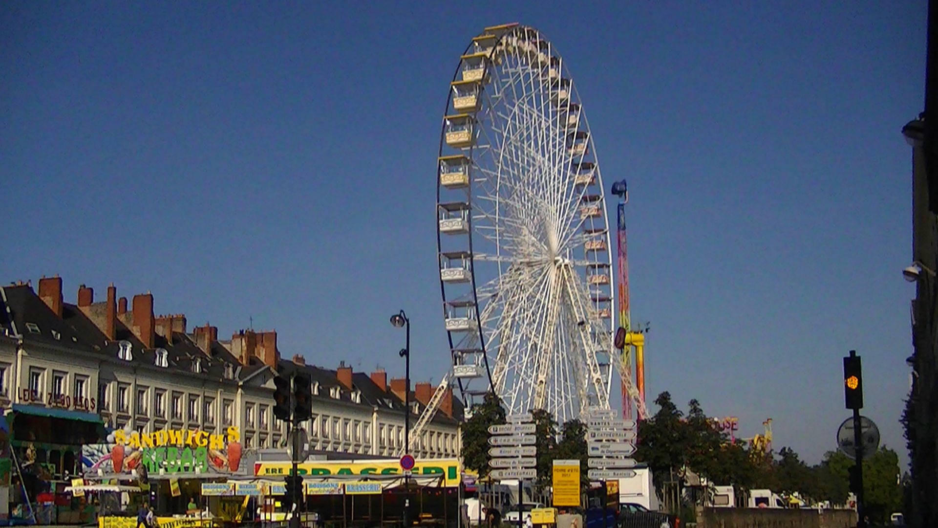
The Foire de Nantes in Spring, 2012. The medieval walls were
destroyed to make room for those buildings on the left.
One way of asserting French control over all of Brittany was by building new walls in Nantes and several other cities. At the time, Nantes was outgrowing its Roman wall, which was partly in ruins. Nantes' new walls were built around 1220. They were much bigger and thicker than the Roman wall, and covered about twice the area of the old wall.

In the south and the east, they simply replaced the old wall. In the south they followed the old course of one of the branches of the Loire River, which has since been covered over. The course of the river is now a major road, a tram line, and a pedestrian area, and the river itself is about a kilometre to the south. In 2011 the city was renovating the roads and sidewalks, and there were a few archaeological digs among the construction sites where bits of the medieval walls and the old port were visible. All that has been covered over again, but the
Porte St-Pierre, remnant of the main
medieval gate of Nantes.
ruins of the wall are still there under the sidewalk.

Beyond that was the river and its various islands, some of which are now connected to the mainland: the university housing for foreign researchers where I first lived in Nantes is located on what used to be on an island in the Loire, a few minutes walk south of the archaeological dig in the above picture.

At the southeast corner of the Roman wall, a new castle had just been built when the French took control in the early 13th century (which eventually grew into the castle that is still there today). The new walls enclosed this castle; I suppose the walls of the castle itself are also technically part of the medieval walls, but I'm not exactly sure how they are related, and I'll write more about the castle later anyway.

From the castle, the walls ran north along the Roman wall. Most of the old wall was destroyed but there are small bits of it built into the medieval part. This is the longest and best-preserved section of the medieval walls, from Rue Prémion up to the Porte St-Pierre. Along Cours St-Pierre, you can also see one of the medieval towers, the Tour St-Laurent, just beside the cathedral.

Porte St-Michel in Guérande,
probably similar to what Porte
St-Pierre used to look like.
Twice a year, in the spring and the fall, there is a small carnival, the Foire de Nantes, along Cours St-Pierre and Cours St-Andre.
This part of the wall is not really accessible for those two months while all the carnival trailers are parked against it. I was always amused to see that the Tour St-Laurent was the spot where all the carnival workers set up their satellite dishes.

The cathedral originally did not extend past the Roman and medieval walls, but when it was completed in the 19th century, the walls were destroyed to make room for the new apse. But there are extensive ruins at Porte St-Pierre, the main gate into the medieval city. Not much remains of the Porte now. There is a sidewalk passing through the original gate, which now just looks like a covered walkway. There is a much wider road running past it, and a wide open square in front of it. There are some enormous neoclassical 18th century buildings around the square, which is also one of the main bus terminals. One of the few statues in France of Louis XVI, the king killed during the Revolution, is also located there. But in the Middle Ages, there would have been nothing but a massive, imposing stone wall and towers. It would have looked more like the main gate of Guérande, further to the west in (historical) Brittany, where the walls and towers are still intact.

Ruins of the towers of Porte St-Pierre.
At Porte St-Pierre, the walls turned to the west, but not exactly following the old wall. As far as I know, there is nothing left of
More ruins under Porte St-Pierre
this northern part of the medieval walls. They were all destroyed to make way for the neoclassical buildings, like the building that is currently the Prefecture of the Loire-Atlantique department. The walls here extended a bit further to the north than the Roman wall, so that the street I lived on, for example, was included within the walls. The Roman wall also did not extend all the way to the Erdre, but the medieval walls did. If my apartment had existed in the 13th century, when walking out my door I would have been facing the tower at the northeastern entrance to Nantes and
the "Port Communeau", the city's northernmost port on the Erdre. Now, the Erdre is blocked off there and diverted to the Loire through a canal underneath Cours St-Pierre.

Tour du Haut-Pas
The old course of the river is now the Cours des 50-Otages, and another large section of the walls is visible at the point where they crossed the Erdre to encircle the medieval suburb of Marchix (or St-Nicolas). Or at least, they were visible when I lived in Nantes. This remnant of one of the walls, and part of a tower, were
covered over by some other buildings in the 19th century.  Those buildings were knocked down while I was there, and when I briefly visited Nantes again in 2014, a new building had already been built in front of it. 

The new building that now covers the Tour du Haut-Pas.
Reconstruction of the Tour du Haut-Pas and Porte Sauvetout,
on a sign in front of the construction site on Cours des
50-Otages in 2012. This part of the walls controlled access to
and from the western suburbs, but also access to the Loire
when sailing down the Erdre.
This section was part of a complex series of towers and moats. During the construction and the archaeological dig, there was a helpful map from the Archaeological Society showing what the area used to look like. This small tower was the Tour de Haut-Pas, and it led to a
Remains of Porte Sauvetout.
much bigger tower, the main gate of the city in the Marchix quarter, Porte Sauvetout. All that is left of Porte Sauvetout is a small section, just a few metres high at most. It's located along one of the tram lines just south of the Tour Bretagne, and can be quickly found from Cours des 50-Otages by climbing the stairs beside the new building that has been built over the Tour de Haut-Pas. It was evidently built at the same time as the walls of the castle, with the same alternating lines of large stones and thinner stone bricks - sort of a medieval version of the way the Roman wall was built. The other remnants of the medieval walls don't look like that, they are just plain rocks.
 
Remains of the wall outside the Basilique St-Nicolas.
The last notable section of the medieval walls really is just a hunk of rocks, and not very well preserved. From Porte Sauvetout, following the wide pedestrian walkway south towards the Basilique St-Nicolas, you'll eventually see this part of the walls just outside the entrance to the basilica.

Marchix/St-Nicolas was the focal point of Nantes in the 18th and 19th centuries, so the area is now full of neoclassical and Second Empire architecture. There is the neo-Gothic
basilica, Place Royale and it's fountain, the Palais de la Bourse which is now a FNAC store, the Théâtre Graslin and the Cours Cambronne - all of which are very impressive, and I'll mention some of them in more detail later. Nantes is certainly a very interesting city if you're a fan of that period of architecture. But for a medieval historian like me, they are also reminders that the medieval suburb and its walls no longer exist!

Wednesday, July 10, 2013

Church of St-Jacques

Façade of St-Jacques.
Location: 47° 11′ 47″ N, 1° 32′ 17″ W

St-Donatien, St-Similien, and most other churches in Nantes are built on ancient or medieval sites, but as far as I am aware, only one, the Church of St-Jacques de Pirmil, is actually the original church (more or less). St-Jacques was built in the 12th century, and restored in the 19th.

The Quartier Saint-Jacques is the only neighbourhood of modern Nantes located on the south bank of the Loire. It used to be called Pirmil, which is still the name of the local tram/bus station.

In the 12th century, Nantes was much smaller, and Pirmil was far outside the walls. The Loire was also much different at the time. Currently, Nantes has only one large island, the Île de Nantes, but this is basically an artificial island created over the centuries by filling in the various branches of the Loire and Erdre rivers. Those branches formed dozens of smaller islands, which were joined together to create one large one. In the Middle Ages, there was just one long bridge connecting Nantes in the north, the islands in the Loire, and Pirmil in the south. At the Pirmil end of the bridge, a castle was built in the 14th century, to protect Nantes during the Hundred Years' War between France and England. The castle has since been destroyed and nothing remains of it.


The church was built in 1180 (as noted by an inscription inside, although that was added much later). A "medieval church" probably brings to mind a Gothic cathedral, like Notre-Dame in Paris, which was actually built around the same time as this church. The Gothic style of Notre-Dame spread to Nantes later; the cathedral in Nantes is another good example of a huge Gothic church, and I'll definitely write more about that later. St-Jacques is still in the Romanesque style though - the architecture and the decorations are rounder, less massive, and less ornate. Romanesque is based on architecture from the late Roman Empire, hence the name: in fact, in French it is simply (and a bit confusingly) called "Roman."

The facade looks old, and it does contain bits of the original church, but it was actually rebuilt in the 19th century.  Most of the interior is from the original Romanesque church. The most interesting parts of the inside are the 12th-century capitals, the top part of a column (although they aren't on their original columns anymore).

Another example of a similar door
from a 12th-century Romanesque
church (at the much more famous
Fontevraud Abbey, near Angers)
St-Jacques actually is a national historical monument, but it's not really a major tourist site, so it's not open to the public. Like the other churches, I had to visit it at the end of Mass one Sunday. It's small, so like at St-Similien, I was easily recognized as a new person. This time, the church's cantor noticed me, and once I explained why I was there (the 12th century is, of course, the best of all centuries), he wanted to point out all the original architecture, especially the capitals.

Restored 19th-century
exterior.
But as usual, the church had to close after Mass. They actually closed it so quickly that they almost locked me inside. I never had another chance to visit it again, which is unfortunate, especially since my pictures all turned out kind of blurry.


Apse of St-Jacques.


The three 12th-century capitals.


The altar and apse.


I couldn't zoom in any more clearly than this, but there is
a small inscription there, the date "1180"


Chapelle Notre-Dame-de-Bonne-Garde

Location: Rue de Bonne Garde
 
Just down the street from St-Jacques is the small Chapelle Notre-Dame-de-Bonne-Garde, which always seems to be open, although I never saw anyone inside. It's not as old at St-Jacques; it was originally built in the mid-17th century, but it was also rebuilt in the 19th century. When it was originally built, it would have been the last chapel on the road away from Nantes, towards Clisson to the south.


Hôpital St-Jacques 


The Church of St-Jacques used to be the chapel of a Benedictine monastery. The monastery itself no longer exists, but the church is now just outside a large hospital, the Hôpital St-Jacques. It's a national historical monument too, and it is always open, but it's also a functioning hospital so I didn't wander around too much.

At the entrance there are these two statues. I don't know who they are, but I would guess Hippocrates and Asclepius. They don't seem to be labelled, but I'm sure there are clues in the statues themselves that art historians would recognize!